
Program Areas - Natural Resources
Program Manager: Shari Miller (757) 824-2327
Wallops Flight Facility (WFF)
- Adjacent to two wildlife refuge areas; and in close proximity to another.
- Situated along the Atlantic Flyway for a wide variety of migratory bird species.
- Beaches are habitat for nesting and foraging threatened and endangered shorebirds.
Our activities have the potential to impact protected species!
Endangered Species Act (ESA)
As a Federal agency, WFF is held to the terms and conditions of the ESA. The ESA was designed to protect species designated by the U.S. Fish and Wildlife Service and the National Marine Fisheries service as threatened or endangered. It prohibits the "taking" of a protected or endangered species.
Taking is defined as: harass, harm, pursue, hunt, shoot, wound, kill, capture, trap, or collect. Harm can be defined as "an act that actually kills or injures wildlife." Such an act may include significant habitat modification or degradation where it actually kills or injures wildlife by significantly impairing essential behavior patterns, including breeding, feeding, or sheltering .
Penalties
Actions by individuals which result in an intentional "take" may result in penalties of up to $100K and one year in prison.
Actions by organizations which result in an intentional "take" may result in penalties of up to $200K and one year in prison.
Protected Species likely to be affected by WFF actions:
- Piping plover
- Red knots
- Bald Eagle
Current Protection Measures:
Each year, in cooperation with the U.S. Fish and Wildlife Service, WFF closes portions of Wallops Island to recreational use to help protect nesting piping plovers, designated as a federally threatened species under the ESA. Piping plover typically begin to arrive at Wallops Island in mid to late March and leave by early fall.
Two areas on Wallops Island are designated piping plover nesting areas. The first area, on the northern end of Wallops Island, abuts the recreational use beach, separated by a cable barrier and signs. Vehicle and pedestrian access north of the cable is prohibited unless expressly authorized by the Environmental Office. The second area is on the southern portion of Wallops Island and extends from Camera Stand Z-100 south to the Assawoman Island property line and is closed year round. Again, authorization from the Environmental Office is required to access this area.
The Environmental Office monitors the Wallops beaches regularly for nesting plover and may open portions of the nesting area to recreational use, or conversely, close portions of the Recreational Beach as circumstances warrant.
One area on Wallops Island is open for permanently-badged Wallops employees and their escorted guests to enjoy for recreational use. Pedestrians and off-road-vehicles (ORVs) can gain access to the area via the dirt road and dune crossing northeast of Camera Station V-100. Please note that the road leading to the dune crossing passes through the former Navy radar site. The road is open for public use but please exercise caution when transiting through this area. This crossing is clearly marked and is the only authorized ORV access point. Except for this crossing point, ORVs are not to be driven on or over dunes or into the closed area.
The beach area north of the access walk across from V-24 is closed to pedestrian and vehicular use effective March 15 and will reopen on September 1. All beach areas south of V-24 are permanently closed without express authorization of the Range and Mission Management Office.
If you have any questions about the Recreational Beach, please contact Shari Miller at 757-824-2327 or by e-mail.
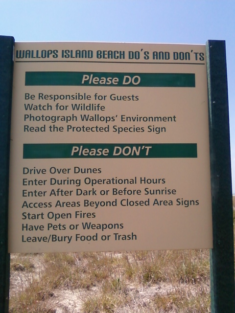
Informational Signs Posted Along Off Road Vehicle (ORV) Entrance to Wallops Island:
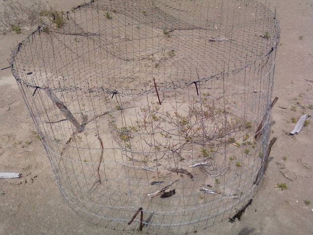
If piping plover should happen to nest on the recreational beach, a wire exclosure will be placed around the nest and warning signs will be placed. Please be vigilant of the piping plover this time of year (March through September). For those of you driving on the Recreational Beach please avoid the soft sand and drive along the intertidal zone only. Piping plover and their eggs are very difficult to see and they can easily blend in with the sandy background.
For more information regarding the identification of protected species on Wallops Island please click on the following link:
Protected Species Identification Training
Wetlands
Once considered useless, wetlands have been discovered to fulfill valuable ecological functions. They offer nurseries for fish species, foraging grounds for waterfowl, filter pollutants from stormwater runoff, and their primary productivity forms the basis of the food chain. It has been the policy of the federal government since the early nineties that there be "no net loss" of wetlands. This means that for every square foot of wetlands destroyed, at least one square foot of new wetlands be created.
Of the 4200 acres that comprise Wallops Island, approximately 2800 acres are considered wetlands. Since most of the "dry" areas of the Island have been developed, this means that every new building project on Wallops Island will have some sort of wetland impact.
The Environmental Office determines the extent and location of wetlands on WFF property, permits wetlands impacts, and arranges the compensatory wetland mitigation that is required by federal, state, and local laws.
Wildlife Management
Operation of a research airport in the wildlife-rich environment in which Wallops Flight Facility is situated necessitates some wildlife control measures. Therefore WFF has contracted with the Department of Agriculture's Wildlife Service (WS) to control the deer population on the Main Base and to institute methods to frighten birds off the runways. The WS also culls the deer population on Wallops Island and traps predators on the Island that prey on endangered species.
