
Program Areas - Cultural & Historical Preservation
Program Manager: Irene Romero, Cultural Resource Manager (301) 286-0469
Programmatic Agreement for the Management of Cultural Resources at NASA Wallops Flight Facility
In accordance with Sections 106 and 110 of the National Historic Preservation Act, NASA Wallops Flight Facility has developed a Programmatic Agreement (PA) with the Virginia State Historic Preservation Officer, Advisory Council on Historic Preservation, the Pocomoke Indian Nation, and the Catawba Indian Nation to outline how the facility will manage its cultural resources as an integral part its operations and missions. The Programmatic Agreement establishes the parameters for managing cultural resources at WFF including:
- Roles and responsibilities
- Updates and requirements for the WFF ICRMP
- Activities not requiring review
- Review process for potential impacts including professional qualifications, documentation, curation, etc.
- Requirements for the treatment of the Wallops Beach Live Saving Station
- Resolution of adverse effects and disputes
- Emergency actions
The Draft PA is still available here.
Cultural Resources Assessment (CRA) - November 2003
This study is an assessment-level investigation of the entire Wallops Flight Facility (WFF) and was sponsored by WFF to assist in meeting its obligations under Section 106 and Section 110 of the National Historic Preservation Act (NHPA) of 1966, as amended. The NHPA requires all Federal agencies to identify, inventory, evaluate and protect properties listed, or eligible for listing, in the National Register of Historic Places (NRHP). Briefly, Section 106 addresses project impact issues and Section 110 addresses overall historic property resource inventory and stewardship issues. For the study, cultural resource specialists conducted background research, a windshield survey (archaeology and historic structures), and a selective reconnaissance-level architectural survey. This study supersedes an earlier cultural resource assessment prepared on behalf of WFF in 1991; it implements necessary technical updates to the earlier study and addresses Virginia Department of Historic Resources (VDHR)/Virginia State Historic Preservation Officer (SHPO) comments on the earlier study.
According to the NHPA, the age criterion for consideration of an historic property is 50 years. For planning purposes, this study evaluated properties constructed prior to 1955. Additionally, the CRA established a predictive model for understanding the archaeological potential over the entire WFF property. The CRA determined that among the cultural resources at WFF there are eight archaeological sites and a total of 166 structures that are at least 55 years old. In a letter dated December 4, 2003 VDHR concurred with the findings of the CRA. The VDHR accepted the predictive model for archaeology at WFF, noting that many of the areas with moderate to high archaeological potential are unlikely to be disturbed by future construction or site use. NASA intends to revisit and update these predictive models in the near future when funding becomes available.
Historic Resources Survey and Eligibility Report - December 2004
Following the initial reconnaissance survey in the CRA, historic research and an intensive-level historic resources survey were conducted to develop an historical context for WFF, specifically concentrating on the structures built from 1936 to 1955 by the U.S. Coast Guard, the U.S. Navy, and the National Advisory Committee for Aeronautics (NACA). The context focused on the development of WFF and its structures and their relation to the Space Race (1957-1969) and Cold War (1945- 1989) eras. This context provided the necessary information with which to make NRHP eligibility determinations for the surveyed buildings and structures constructed prior to 1956.
Historic research on the 166 structures identified in the CRA narrowed the eligibility assessment to 124 buildings. Of those, two resources - the Wallops Beach Lifeboat Station (VDHR #001-0027-0100; WFF# V-065) and its associated Coast Guard Observation Tower (001-0027-0101; WFF# V-070) - were determined to be eligible for listing in the NRHP and Virginia Landmarks Register (NASA, 2004). The other surveyed resources were determined not to be NRHP eligible because they lacked the historical significance or integrity necessary to convey significance due to additions and other alterations to the original building fabric. In a letter dated November 4, 2004, the VDHR concurred with the findings and determinations in the Historic Resources Survey and Eligibility Report, confirming that the Wallops Coast Guard Lifesaving Station is eligible for listing in the NRHP, with the Observation Tower as a contributing structure to the historic property (NASA, 2004).
Historic Resources Survey and Eligibility Report - August 2011
This survey was a continuation of NASA's phased program of identifying, evaluating, and protecting cultural resources at WFF. The survey built upon the 2004 HRES Report that recorded resources built before 1956. The 2011 survey documented a total of 76 facilities at WFF dating between 1956 and 1965 and was completed in three stages. First, archival research was conducted to create a historic context of the facility; second, a field survey was completed to gather information on the architectural design, construction, and integrity of the resources; and third, archival research and field survey information were analyzed to determine the eligibility of each resource for inclusion in the National Register of Historic Places (NRHP), both individually and as a historic district. All buildings and structures were documented in accordance with the Virginia Department of Historic Resource's (VDHR) standards and guidelines and evaluated to determine potential significance in accordance with the National Register Criteria for Evaluation. The survey did not identify any National Register-eligible districts. The surveyed resources were recommended not individually eligible for inclusion in the National Register because each lacks significance and/or integrity.
Integrated Cultural Resource Management Plan
An ICRMP was completed for WFF as an internal management and compliance plan designed to assist NASA in meeting its obligations under Section 110 of the NHPA. The ICRMP outlines how WFF will manage its cultural resources as an integral part of the existing framework of its operations and mission and is designed to provide a program that will facilitate cultural resources coordination, planning and compliance activities. The WFF ICRMP provides procedures and recommendations for cultural resource management that are specific to WFF. It identifies current administrative, operations, planning, and maintenance decision-making processes that may affect cultural resources at WFF. It recommends strategies for maintaining those resources and complying with Federal, State and NASA regulations. The ICRMP is intended to be a dynamic tool that is reviewed and updated as conditions, goals, and objectives change over time.
Historic Resources Survey and Eligibility Report – June 2018
An additional survey was completed in June 2018, continuing NASA's phased program of identifying, evaluating, and protecting cultural resources at WFF. This version of WFF's efforts to identify potential historic resources builds upon the 2004 and 2011 HRES Reports. The 2018 survey documented an additional 51 facilities at WFF dating between 1965 and 1981. The SHPO agreed with NASA's determination that none of the 51 facilities were historic.
Wallops Beach Lifeboat Station and Observation Tower
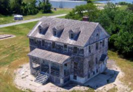
The Wallops Beach Lifeboat Station and Observation Tower were constructed in 1936 as the second government life saving station on Wallops Island, the first being constructed in 1883 by the United States Life-Saving Service. The 1883 station was destroyed by a hurricane in August of 1933. The Coast Guard operated the Wallops Beach Lifeboat Station and Observation Tower as an adjunct to the main station on Chincoteague Island. From 1936 to 1947, the Station's mission was to rescue sailors from sinking vessels and save cargo from damaged ships. Wallops Beach Lifeboat Station rescue boats reached open sea through a channel and boat basin dug to the rear of the island off Sloop Gut that provided access from Ballast Narrows to open ocean via the Chincoteague inlet. The Wallops Beach Lifeboat Station building was primarily living quarters for the life saving station personnel. Because the Wallops Beach Lifeboat Station was located inland from the shore, an observation tower was constructed during the same period.
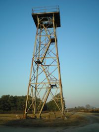
The Wallops Beach Lifeboat Station and Observation Tower have been evaluated as a combined individual resource, with the Observation tower as a secondary, contributing structure. Issues of significance, integrity, and boundaries were carefully considered. The Wallops Beach Lifeboat Station and Observation Tower are eligible for listing in the NRHP and the Virginia Landmarks Register as a single resource under Criterion A for its association with the Coast Guard on the local level with the period of significance as 1936-1947 and Criterion C in the area of Architecture on the local level, with the period of significance as 1936 (the Observation Tower is not significant individually but as a contributing structure to the Lifeboat Station). The Wallops Beach Lifeboat Station and Observation Tower retain the necessary aspects of integrity, including location, design, setting, materials, workmanship, feeling, and association, to be eligible for the NRHP (Historic Resources Survey and Eligibility Report for Wallops Flight Facility, Accomack County, Virginia, 2004). Accomack County, Virginia, 2004).
Revolutionary War Fort Footprint discovered on North Wallops Island
In July of 2009 a cultural resources inventory and assessment was performed for north Wallops Island. The only historical resource discovered was the well preserved remnants of an earthwork fort dating to the Revolutionary War (Site 44AC0089).
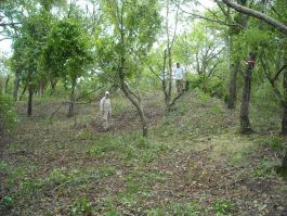
The fort acted as a small, coastal battery to restrict enemy boat/ship activity, however, the Wallops Island fort did not play a major role in the Revolutionary War and was not involved in any major battles that changed the course of the conflict. Although the fort provided protection to ships loyal to the Continental cause, that protection was fleeting, as demonstrated by the ease with which the fort was taken. From the literature on this fort, it appears that it was lightly manned, and that the personnel probably resided in the earthwork proper. There are very few surviving examples of small, coastal defenses from the Revolutionary War. This increases the importance of the remaining examples in terms of providing insight into vernacular military construction. The site has the integrity to allow for design and construction methods to be addressed. The fort also has sufficient integrity of setting to allow for meaningful public interpretation. A visitor standing in the fort looks out at a view minimally changed since the Revolutionary War, and can readily understand the reasons for constructing a fort at this location. The fort is recommended eligible for the NRHP under Criterion C and D, and the local level of significance.