
Programmatic Environmental Impact Statement for the Shoreline Restoration and Infrastructure Protection Program (SRIPP)
- National Environmental Policy Act
- Wallops Flight Facility
- Background
- Purpose for the Proposed Action
- Need for the Proposed Action
- Project Components
- New Project Information
- Summary Table of Proposed Action Alternatives
- Public Involvement
NASA issues a Record of Decision (ROD) for the SRIPP! In the ROD, NASA selected its preferred alternative, Beach Fill Only and Seawall Extension, for implementation. NASA will now apply for all necessary permits such that seawall construction can begin in spring 2011. Beach fill is expected to start in winter 2011.
The Final SRIPP PEIS and its Appendices are available online and may be viewed here.
The Draft SRIPP PEIS and its Appendices are still available online and may be viewed here.
National Environmental Policy Act
The National Environmental Policy Act of 1969 (NEPA) established a national policy to protect the environment by requiring Federal agencies to consider the effects of their actions on the human environment prior to implementing said action(s) and to give the public the opportunity to participate in the planning process. The National Aeronautical and Space Administration (NASA) prepared a Programmatic Environmental Impact Statement (PEIS) to consider the potential effects from its proposed Shoreline Restoration and Infrastructure Protection Program (SRIPP). The PEIS was developed to fulfill NASA's obligations under the National Environmental Policy Act of 1969, the Council on Environmental Quality's (CEQ) regulations implementing NEPA (40 Code of Federal Regulations [CFR] Parts 1500 through 1508), and NASA's Procedural Requirements (NPR) for implementing NEPA (NPR 8580.1).
NEPA Process Poster
Proposed Shoreline Restoration and Infrastructure Protection
Wallops Flight Facility
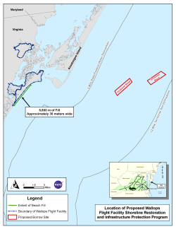
NASA Goddard Space Flight Center's Wallops Flight Facility was established in 1945 by the National Advisory Committee for Aeronautics as a center for aeronautics research, and is now NASA's principal facility for managing and implementing suborbital research programs. WFF is located in the northeastern portion of Accomack County, Virginia, on the Delmarva Peninsula, and is comprised of three land masses; the Main Base, Wallops Mainland, and Wallops Island. Wallops Island comprises approximately 1,680 hectares (4,600 acres), is bounded by Chincoteague Inlet to the north, Assawoman Island to the south, the Atlantic Ocean to the east, and estuaries to the west, and is the location of the proposed SRIPP at WFF.
Background
Wallops Island has been subject to the effects of shoreline retreat well before NASA's presence on the island was established in the mid-1940s, with measured losses averaging approximately 3.7 meters (12.2 feet) per year since 1857. Shoreline retreat has been caused by both natural and man-induced processes. The ocean has encroached substantially toward launch pads, infrastructure, and test and training facilities belonging to NASA, the U.S. Navy, and the Mid-Atlantic Regional Spaceport.
NASA has made several attempts to prevent continued shoreline retreat using several different erosion control measures including the establishment of wooden groins and experimental berms, construction of a rock seawall, and the installation of geotextile tubes (geotubes). Despite these efforts, the ocean has continued to encroach substantially toward the valuable infrastructure on Wallops Island.
Purpose for the Proposed Action
The purpose of the Proposed Action is to reduce the potential for damage to, or loss of existing NASA, U.S. Navy, and MARS assets on Wallops Island.
Need for the Proposed Action
The Proposed Action is needed to ensure the continued ability of NASA, the U.S. Navy, and MARS to serve the nation's rapidly growing civil, defense, academic, and commercial aerospace requirements. Additionally, WFF and MARS are located within the only research range in the U.S. that is wholly controlled by NASA, and as a result, WFF is the only research range in the world that is solely under NASA control and focused on NASA's schedule, budget, and mission objectives.
Currently, assets on Wallops Island are valued at over $1 billion and are increasingly at risk from extensive shoreline retreat. The risks to WFF could cause the interruption of missions and/or permanent loss of capabilities supported by the facility. The SRIPP would help reduce the risk to infrastructure on Wallops Island by restoring the shoreline, which would provide protection for infrastructure on the island.
Project Components
NASA and the U.S. Army Corps of Engineers investigated various engineering alternatives for this project, which included the following project components:
- Extension of the existing seawall by approximately 1,500 feet to a maximum of approximately 4,500 feet to the south;
- Initial dredging of approximately 3 million cubic yards of sand from a borrow site located in Federal waters and subsequent sand placement on the Wallops shoreline;
- Biannual shoreline monitoring and adaptive management;
- Maintenance dredging to be performed every five years for the duration of the project's 50-year design life, with approximately 1 million cubic yards of sand per cycle from the same borrow site; and
- One sand retention structure on the south end of Wallops Island.
The USACE performed a study in September of 2006 on Beach Erosion Mitigation and Sediment Management Alternatives for Wallops Island. The results of this study served as a basis for NASA's consideration of a wide range of project alternatives. NASA considered three alternatives, with Alternative One being the Preferred Alternative under the Proposed Action. All three alternatives would provide Wallops Island facilities equal levels of storm damage reduction.
New Project Information
Following a thorough analysis of the sand transport patterns within the project vicinity, NASA has identified a new Preferred Alternative (Alternative 1) that would involve beach fill and seawall extension only. The Preferred Alternative would not include sand retention structures (i.e. breakwaters, groins).
After surveying commercial and recreational fisherman and analyzing the potential effects of dredging Blackfish Bank, NASA has removed the Blackfish Bank Shoal as a proposed source of sand for the SRIPP. A new unnamed shoal (Unnamed Shoal B), approximately 1.5 nautical miles east of Blackfish Bank, will now be considered in addition to the original Unnamed Shoal (Unnamed Shoal A) as a potential borrow site.
As requested at the December 2009 Public Update Meeting: Benthic habitat video from selected video stations on Unnamed Shoal A (camera station 26) and Unnamed Shoal B (camera station 14) are now available. Corresponding camera station location maps for Unnamed Shoal A and Unnamed Shoal B are also available. (Please be patient as larger file sizes may take longer to download).
Two and three-dimensional images of the proposed borrow sites (Unnamed Shoal A and Unnamed Shoal B) are available.
Summary Table of Proposed Action Alternatives
| Alternative | Proposed Action | Options |
|---|---|---|
| Alternative 1 (Preferred Alternative) | Full Beach Fill, Seawall Extension | Option 1 – Unnamed Shoal A Borrow Site Option 2 – Unnamed Shoal B Borrow Site |
| Alternative 2 | Full Beach Fill, Breakwater, Seawall Extension | Option 1 – Unnamed Shoal A Borrow Site Option 2 – Unnamed Shoal B Borrow Site |
| Alternative 3 | Full Beach Fill, Terminal Groin, Seawall Extension | Option 1 – Unnamed Shoal A Borrow Site Option 2 – Unnamed Shoal B Borrow Site |
Independent Technical Review (ITR) of PEIS
NASA is committed to ensuring that the analyses and conclusions drawn in the SRIPP PEIS are validated in an independent manner by a team composed of world-renowned coastal scientists and engineers. Therefore an ITR of the document was completed by Coastal Research Associates (CRA), a specialized firm composed of Dr. Robert Dolan (University of Virginia), Dr. Michael Fenster (Randolph-Macon College), Dr. Robert Dean (University of Florida), and Dr. Laura Moore (University of Virginia).
Public Involvement
NASA published a Notice of Intent (NOI) to prepare the SRIPP EIS and conduct scoping in the March 24, 2009 edition of the Federal Register.
The purpose of scoping is to allow the public an early opportunity to provide input regarding NASA's proposal, the alternatives being considered, and significant environmental issues to be addressed in the EIS.
Through the scoping process NASA has identified and met with various stakeholders. Their comments are being considered and incorporated into the SRIPP design plan when possible.
Meetings
NASA held a public comment meeting on the Draft SRIPP PEIS at Wallops Flight Facility Visitor Information Center on March 16th, 2010. Minutes from the meeting were recorded and are available here.
NASA held a public update meeting on the SRIPP at Wallops Flight Facility Visitor Information Center on December 8th, 2009. A presentation was given illustrating the changes to the project in response to public comments received through the scoping process and additional project analysis. A new Preferred Alternative was presented that involved beach fill only.
NASA held a public scoping meeting on the SRIPP at Wallops Flight Facility Visitor Information Center on April 21st, 2009. Announcements advertising the scoping meeting for the SRIPP were published in three local newspapers. Follow these links to view the presentation, meeting minutes, and the scoping comment summary.
Surveys
As part of the EIS planning process NASA conducted a fisheries survey requesting input from concerned parties to the following question: "Will the SRIPP directly or indirectly impact commercial and/or recreational fishing?" Responses were requested by May 15, 2009. The results to the survey can be found by clicking on the link below:
Fisheries Impact Survey Results
Document Review
The FINAL SRIPP PEIS is available for review at the following locations:
Chincoteague Island Library, Chincoteague, VA
Eastern Shore Public Library, Accomac, VA
Northampton Free Library, Nassawadox, VA
NASA WFF Technical Library, Wallops Island, VA
NASA Headquarters Library, Washington D.C.
A limited number of hard copies of the FINAL SRIPP PEIS are available by contacting:
Shari Miller
NASA Wallops Flight Facility
Mailstop: 250.W
Wallops Island, Virginia 23337;
fax: 757-824-1819; or
electronic mail at: Shari.A.Miller@nasa.gov.
An electronic copy of the FINAL SRIPP PEIS is available by clicking here.