Operable Unit 07
Background
Operable Unit 07 (OU 07), Construction Debris Landfill, also known as Formerly Used Defense Site (FUDS) Project 15, is a historic waste disposal site first visible as ground scars in aerial photographs from 1949 at the Chincoteague Naval Auxiliary Air Station. The U.S. Army Corps of Engineers (USACE) conducted environmental investigations under the FUDS Program prior to transferring the site to NASA.
History of the Construction Debris Landfill
The Department of Defense (DoD) established the Chincoteague Naval Auxiliary Air Station (CNAAS) in 1943 at the current Main Base portion of NASA's Wallops Flight Facility (WFF) to establish a training facility for World War II naval aviators. The Navy built three runways, several buildings and supporting infrastructure in the early 1940s. The original runways and buildings have been modified and extended, as needed, to accommodate the evolving mission of the facility. Accordingly, the WFF property has experienced periods of construction and demolition of runways, buildings, and roadways. Analysis of historical aerial photographs document a series of ground scars indicative of waste disposal in areas at the northeast corner of WFF that are visible in 1949, 1954, 1959, and 1963 aerial photographs. By 1963, some of these features are no longer visible. By 1974, none of them remained visible. Investigations described below confirmed that the area had been used for disposal of construction debris and ash.
Construction Debris Landfill Site Today
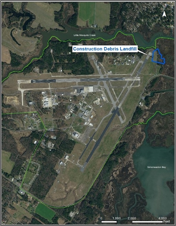
The CDL is in the northeast corner of WFF bounded to the west by Runway 22 and to the north and east by Little Mosquito Creek. The site generally consists of mowed grass with shrubs and trees near Little Mosquito Creek. Construction debris can be found at the surface near Little Mosquito Creek and buried by as much as 11 feet of sand fill further inland. The type of construction debris observed at the Site consists of empty metal drums, paint, scrap metal, rebar, glass bottles, bricks, tires, concrete, and burned rubbish.
 |
 |
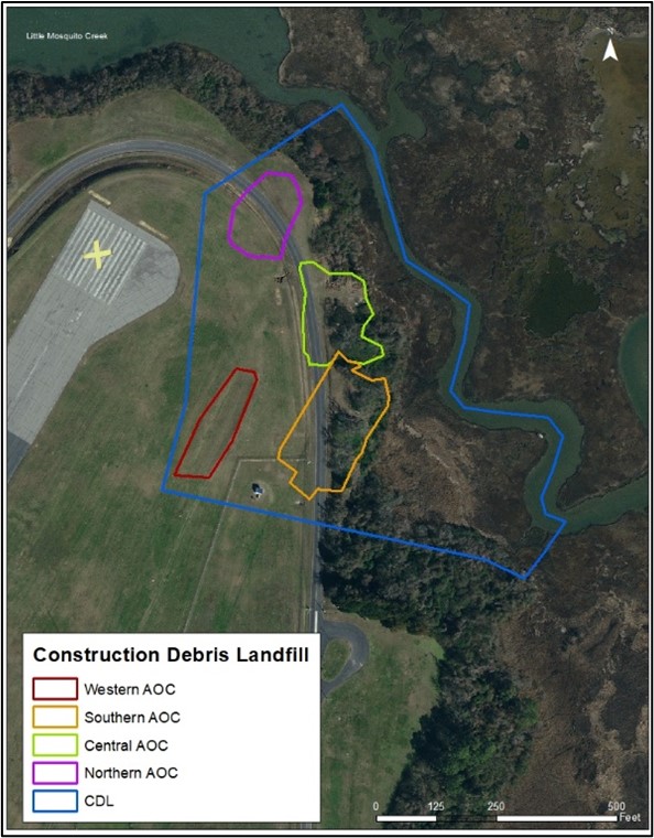
| Map of CDL Location at WFF Main Base | Areas of Concern at CDL |
Previous Investigations
The CDL site was discovered in 2000, when the United States Army Topographic Engineering Center produced a historical analysis report of area ground scars, disturbances, channels, and other activities at WFF dating back to before the United States involvement in World War II. Based on the aerial photographic analysis, four Areas of Concern (AOCs) within the CDL were defined and named with respect to their geographic position to each other: Northern, Central, Southern, and Western AOCs.
- Northern AOC – This AOC was an area of disturbed ground in 1949 that was an excavation in 1954.
- Central AOC – This AOC was an area with several mounds of unidentified material in 1954 and was an excavation by 1959.
- Southern AOC – This AOC was an area of disturbed ground with two man-made channels. The AOC's use as a burning ground was confirmed on a 1950 site map.
- Western AOC – This AOC is interpreted to be a shallow excavation that is now located inside the runway area fence.
In 2015, NASA and the DoD, through the Department of the Army, signed a Memorandum of Agreement (MOA) to transfer funds from DoD to NASA to conduct necessary response actions under the Comprehensive Environmental Response, Compensation, and Liability Act (CERCLA). The MOA was authorized by section 315 of the National Defense Authorization Act for Fiscal Year 2015. In 2021, NASA and USEPA entered into an Administrative Agreement and Order on Consent RCRA-03-2021-0022TH (AAOC) for the FUDS Program. The AAOC designated WFF as a Superfund Alternative Approach site.
During cleanup, complex sites may be divided into several distinct areas to make the response more efficient. These areas, called operable units (OU's), may address geographic areas, specific problems, or medium (e.g., groundwater, soil) where a specific action is required. WFF currently has nine OUs. The CDL is designated as OU 7. Below is a summary of the environmental activities at the CDL.
Limited Site Investigation – In 2002 - 2003, USACE completed a Limited Site Investigation, consisting of soil and groundwater samples from the areas southeast of the Central and Southern AOCs.
Soil Gas Investigation – In 2004, USACE collected a single soil sample from the contaminated soil layer approximately 7.5 feet in depth. The sample was analyzed for volatile petroleum hydrocarbons and gas chromatograph fingerprinting analysis. Results indicated weathered JP-5 aviation fuel was present. USACE then completed a soil gas investigation, which measured elevated levels of benzene, toluene, ethylbenzene, and xylene (BTEX), and chlorinated solvents.
Remedial Investigation – In 2007, USACE conducted a Remedial Investigation (RI), which included geophysical surveys, a membrane interface probe survey, test pitting activities, and soil, groundwater, sediment, and surface water sampling.
Supplemental Field Investigation, Human Health Risk Addendum and Ecological Risk Assessment Addendum – Fieldwork activities for the Supplemental Field Investigation (SFI) was conducted between May 2015 and November 2017. The purpose of the SFI was to determine if the lower part of the surficial aquifer was contaminated and to refine the extent of the waste material within the AOCs. Fieldwork included trenching, soil, groundwater, sediment, surface water, and pore water samples.
In 2022, NASA completed the SFI, which included a Human Health Risk Assessment (HHRA) and Ecological Risk Assessment (ERA). The HHRA evaluated risks to human health potentially posed by Contaminants of Potential Concern in the affected environmental media beneath and within the vicinity of the Site that cannot be eliminated using screening criteria. The ERA identified Contaminants of Potential Ecological Concern for potential ecological receptors and habitats and potentially complete exposure pathways at the Site.
Non-Time Critical Removal Action
A Non-Time Critical Removal Action (NTCRA) to address unacceptable risks associated with landfill waste and affected soils was necessary to address the potential for direct contact by human and ecological receptors.
Engineering Evaluation and Cost Analysis (EE/CA) – In 2022, NASA completed the EE/CA, which identified the objectives of the NTCRA and analyzed the effectiveness, implementability, and cost of alternatives.
Action Memorandum – In 2023, NASA completed the Action Memorandum which documented NASAs decision to conduct a NTCRA which includes excavation and offsite disposal of waste and affected soil.
Sampling and Analysis Plan – In 2023, NASA completed the Sampling and Analysis Plan which outlined the objectives, planned activities, data acquisition, assessment, and data review procedures associated with the pre-excavation soil sampling at the site.
Design Plan – In 2023, NASA finalized the site design, which included erosion and sediment control, drainage, excavation, and site grading designs. The NTCRA began in June 2023 and will be complete by December 2023. Following final grading and site stabilization, NASA will issue a Removal Action Completion Report. Contaminants in groundwater, surface water, and sediment will be addressed in a future Feasibility Study.
For any questions regarding Operable Unit 07, please contact:
Kristi Francisco
Restoration Program Manager
NASA Wallops Flight Facility
Mailstop: 250.W
Wallops Island, VA 23337
kristi.l.francisco@nasa.gov
(757) 824-6704


